Predicting landslide risk using advanced computer modeling

Greg Howard
27th October, 2025

Predicting landslide risk using advanced computer modeling

Technical routs for this research.

Image adapted from: Wang et al. / CC BY (Source)

Key Findings

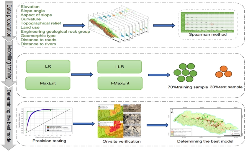
  • This study assessed landslide susceptibility in the mountainous region of northern Xinjiang, China, an area prone to landslides due to steep slopes and complex geology
  • Combining statistical analysis with machine learning (specifically the I-LR model) improved prediction accuracy, achieving an AUC of 0.941, outperforming the I-MaxEnt model (AUC 0.907)
  • Distance to rivers, engineering geological rock group, and slope angle were identified as the most important factors influencing landslide susceptibility in this region
Landslides pose a significant threat in mountainous regions globally, and accurately predicting where they are likely to occur – assessing landslide susceptibility – is vital for effective disaster prevention. The Tianshan Mountains in Xinjiang, China, are particularly prone to these events due to their steep slopes and complex geological conditions. Recent research undertaken by scientists at Xinjiang University & Guizhou University[1] aimed to improve the precision of landslide susceptibility mapping in this economically important area. Historically, distinguishing between genuine landslide risk factors (“signals”) and irrelevant data (“noise”) has been a core challenge in geological hazard assessment[2]. Traditional methods rely on statistical analysis, but these can be limited by the quality of the data and the potential for subjective interpretation. To address this, the study combined established statistical techniques with machine learning models, a more modern approach capable of handling complex datasets. The researchers began by identifying ten factors known to influence landslide occurrence. These included physical characteristics like elevation, slope angle, and the direction the slope faces (aspect), as well as geological properties such as rock type, land use, and proximity to rivers and roads. A key step was analyzing these factors for “multicollinearity” – situations where factors are strongly correlated, which can distort results. To create a robust evaluation system, the team developed two coupled models: the Information Value-Maximum Entropy (I-MaxEnt) model and the Information Value-Logistic Regression (I-LR) model. The Information Value (I) model assesses the predictive power of each factor, while Logistic Regression (LR) statistically estimates the probability of a landslide based on these factors. Maximum Entropy (MaxEnt) uses the available data to predict the distribution of landslides. By combining these, the researchers hoped to leverage the strengths of each approach. The success of any diagnostic system, as highlighted in earlier work[2], hinges on its accuracy. This is typically measured using Receiver Operating Characteristic (ROC) curves, which plot the ability of the model to correctly identify both landslide and non-landslide areas. The area under the curve (AUC) provides a numerical score representing overall accuracy, with higher values indicating better performance. The study found that both the I-MaxEnt and I-LR models performed well, achieving AUC values of 0.907 and 0.941 respectively. This suggests a high level of accuracy in predicting landslide susceptibility. Importantly, the I-LR model showed a significantly higher AUC score than the I-MaxEnt model, indicating superior predictive capability. further validated these findings through field observations, confirming that the I-LR model’s predictions were more consistent with actual landslide locations. The improved accuracy achieved by the I-LR model is attributed to its ability to effectively integrate statistical analysis with machine learning, providing a more reliable assessment of landslide risk in the Tianshan northern slope economic belt. The findings offer a valuable tool for disaster prevention and mitigation efforts in the region, and potentially in other similar mountainous environments.[2] emphasizes the importance of rigorously testing diagnostic systems and acknowledging data limitations, and the validation process employed in this study directly addresses this concern.

AgricultureEnvironmentEcology

References

Main Study

1) Landslide susceptibility assessment via the information value-coupled machine learning models

Published 21st October, 2025

https://doi.org/10.1371/journal.pone.0333055


Related Studies

2) Measuring the accuracy of diagnostic systems.

Journal: Science (New York, N.Y.), Issue: Vol 240, Issue 4857, Jun 1988


Related Articles

An unhandled error has occurred. Reload 🗙