Roads and Wildlife: How Structures Help Animals Cross Forests

Jenn Hoskins
8th September, 2025

Roads and Wildlife: How Structures Help Animals Cross Forests

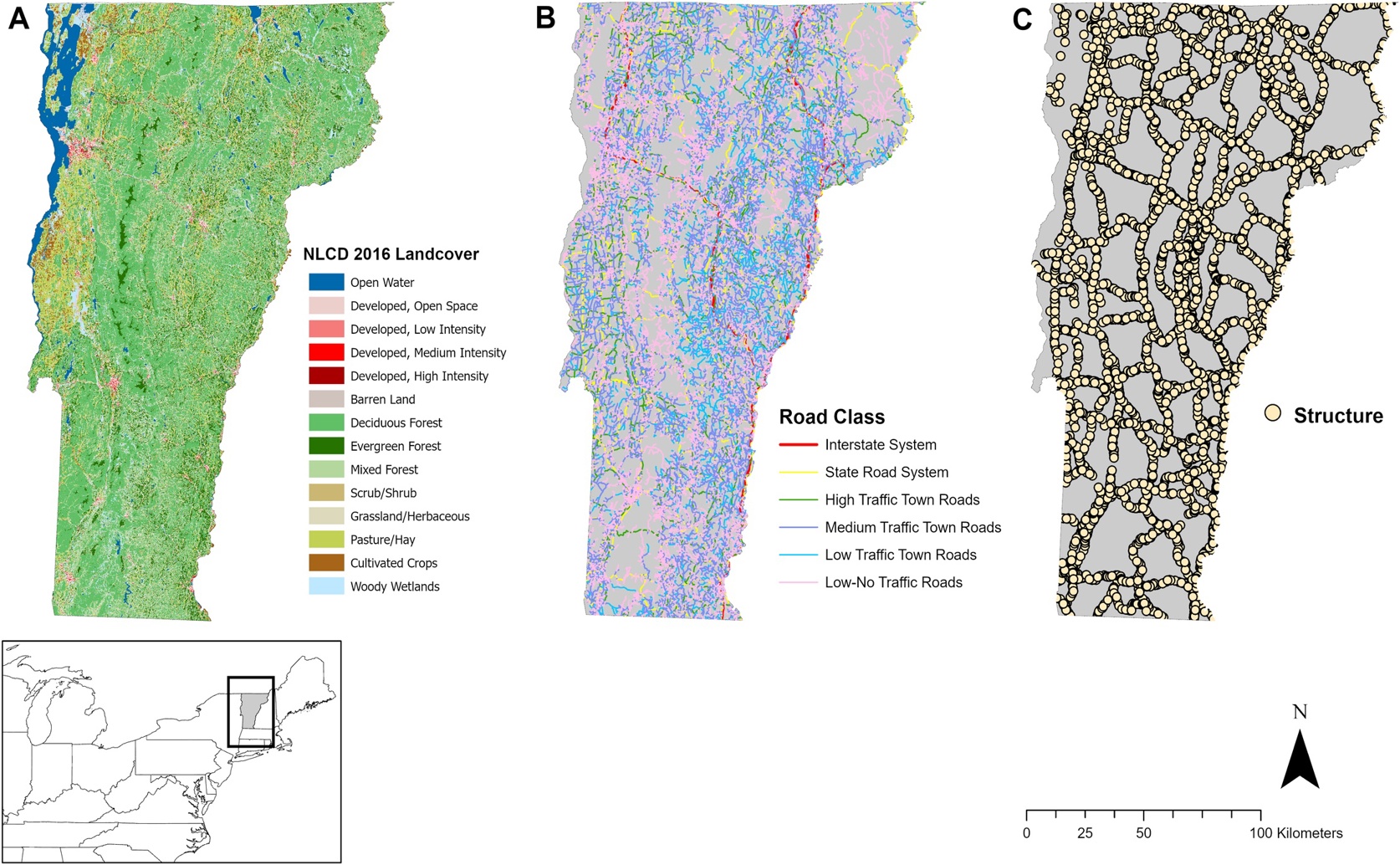
This assessment of landscape connectivity utilized detailed landcover data (a) and roadway classifications (b) to evaluate the capacity of 5,912 transportation structures (c) to facilitate terrestrial mammal movement across the fragmented Vermont landscape.

Image adapted from: Drasher et al. / CC BY (Source)

Key Findings

  • This Vermont study modeled wildlife movement for eight mammal species to identify priority areas for improving road connectivity
  • Forest-dependent animals like black bear showed the highest potential movement through forested areas, while raccoon favored developed landscapes
  • Ranking roadway structures for improvement varied depending on whether the focus was statewide movement patterns or local conditions near the structure
Habitat fragmentation, largely driven by human development like road networks, poses a significant threat to wildlife populations by restricting movement and impacting genetic diversity[2]. Roads create barriers that isolate animal groups, potentially leading to reduced gene flow between subpopulations and increased risk of extinction. While structures like bridges and underpasses can help mitigate these effects, identifying where to best implement these solutions – and assessing their actual effectiveness – remains a challenge. Researchers at the University of Vermont, in collaboration with the Vermont Agency of Transportation and other partners[1], recently undertook a comprehensive study to model wildlife movement across the state of Vermont. This work focused on eight terrestrial mammal species, utilizing a technique called “omnidirectional circuit theory”. This method essentially treats the landscape as an electrical circuit, with areas that are easy for animals to move through acting as low-resistance pathways and barriers like roads as high-resistance areas. The “flow” of electrical current then represents the predicted movement of animals. The study combined expert knowledge of landscape resistance – how difficult different terrain types are for each species – with data on where animals are actually found. This data was used to create species-specific connectivity models at two scales: statewide (covering 23,873 km2) and around individual roadway structures (within a 100-meter radius of 5,912 structures). Results showed clear differences in movement patterns depending on the species. Forest-dependent animals, like black bear, exhibited the highest predicted movement through the forested foothills of the Green Mountains, while those adapted to more developed landscapes, such as raccoon, showed higher movement in agricultural and urban areas. Interestingly, black bear also showed the highest average current density at the statewide scale, while striped skunk had the lowest, indicating a greater potential for movement across the landscape for bears compared to skunks. At the finer scale, raccoon showed the highest movement potential near structures, whereas moose had the lowest. These findings align with earlier research highlighting the negative impact of roads on genetic connectivity[3]. The Vermont study expands on this by demonstrating that the type of road matters significantly. While major highways may create localized barriers, the more widespread network of state roads often has a greater overall impact on connectivity. This is because state roads are more numerous and distributed throughout the landscape, collectively creating a more fragmented habitat. The research also tackled the issue of prioritizing conservation efforts. When evaluating the effectiveness of existing roadway structures, the team found that the ranking of structures varied greatly depending on the method used to combine the statewide and local-scale data. This underscores the importance of clearly defining conservation objectives – are you trying to maximize connectivity for all species, or focusing on specific, at-risk populations? Furthermore, the study emphasized the crucial role of intact forest for maintaining connectivity. Maps generated by the researchers highlighted areas of high forest cover as particularly important for protecting wildlife movement corridors, supporting Vermont’s Community Resilience and Biodiversity Protection Act, which aims to conserve 50% of the state’s land by 2050. This approach provides valuable information for targeted conservation efforts, helping to identify priority regions for protection and guiding investments in transportation infrastructure that benefits both wildlife and people.[2] acknowledges the need for long-term monitoring programs to assess the genetic effectiveness of mitigation efforts, and the Vermont study provides a framework for identifying locations where such monitoring would be most beneficial.

EnvironmentWildlifeEcology

References

Main Study

1) Assessing the connectivity value of roadway structures for terrestrial mammals across the Northern Appalachian forest of Vermont

Published 4th September, 2025

https://doi.org/10.1371/journal.pone.0331493


Related Studies

2) Ability of wildlife overpasses to provide connectivity and prevent genetic isolation.

https://doi.org/10.1111/j.1523-1739.2008.01162.x


3) Do all roads lead to resistance? State road density is the main impediment to gene flow in a flagship species inhabiting a severely fragmented anthropogenic landscape.

https://doi.org/10.1002/ece3.7635


Related Articles

An unhandled error has occurred. Reload 🗙