Understanding Fire Patterns: Identifying Changes and Predicting Seasonal Fires

Jim Crocker
7th April, 2025

Understanding Fire Patterns: Identifying Changes and Predicting Seasonal Fires

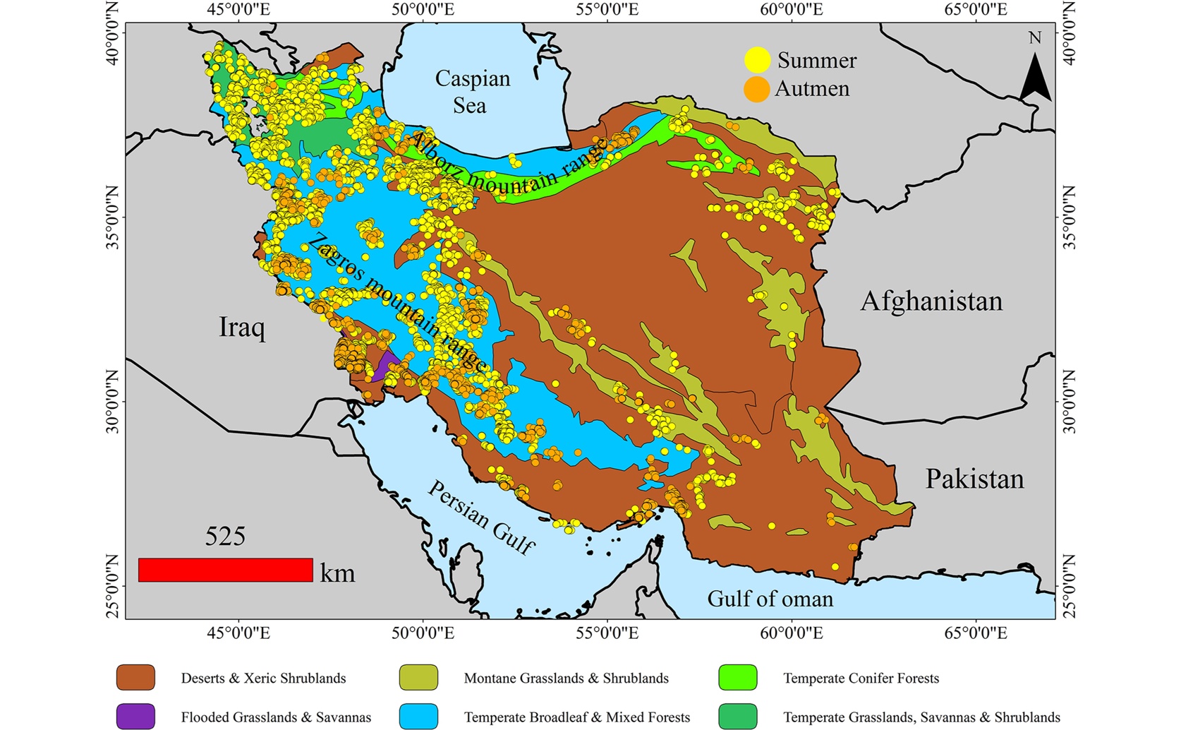
This map displays the locations of wildfire occurrences in Iran that showed a significant increasing trend in density between 2001 and 2023, revealing widespread and seasonally distinct patterns in summer and autumn that are foundational to the study's wildfire risk predictions.

Image adapted from: Karami et al. / CC BY (Source)

Key Findings

  • *In Iran from 2001 to 2023, wildfires have significantly increased during summer and autumn seasons.*
  • *The Zagros Mountains are especially vulnerable, with human activities and soil conditions driving higher wildfire risks.*
  • *Advanced models accurately identify high-risk areas, helping land managers target protection efforts effectively.*
Wildfires pose significant threats to ecosystems, biodiversity, and human activities worldwide. Understanding the patterns and drivers of wildfires is crucial for effective land management and conservation efforts. Recent research conducted by Malayer University, Malayer, Iran; Islamic Azad University, Tehran, Iran; and Bowling Green State University, USA[1] provides valuable insights into wildfire trends in Iran, particularly during summer and autumn seasons from 2001 to 2023. The study focuses on analyzing wildfire complexity by assessing fire density trends and predicting wildfire occurrence probabilities. Fire density, representing the number of fire incidents per square kilometer, is a fundamental aspect of wildfire regimes. By examining these trends, the researchers aim to identify high-risk areas and inform targeted land management strategies to protect vulnerable regions. To achieve this, the researchers utilized active fire data and applied a kernel function to calculate seasonal fire point density. The Mann-Kendall (MK) test was employed to identify areas with significant trends in fire density at a 90% confidence level. These areas were then incorporated into a MaxEnt model, a machine learning tool used for predicting species distribution and, in this case, wildfire risk. The model considered various environmental variables, including average temperature, human modification of terrestrial systems, annual precipitation, precipitation of the driest month, elevation, land use/land cover (LULC), land surface temperature (LST), soil organic carbon (SOC), and wind exposure index (WEI). The study revealed that from 2001 to 2023, there was a significant increase in fire density across large areas of Iran, with 326,739.56 km² affected in summer and 102,668.85 km² in autumn. Notably, there was minimal overlap between regions experiencing increasing and decreasing fire densities across the two seasons, indicating that wildfires are disproportionately impacting both natural and agricultural areas. The Zagros Mountain forest steppes emerged as particularly vulnerable, aligning with findings from a previous study that highlighted the high biodiversity of these regions and their susceptibility to wildfires[2]. Human activities play a crucial role in wildfire dynamics. The MaxEnt model identified human modification of terrestrial systems and SOC as the most significant predictors of wildfire risk. This aligns with earlier research emphasizing the impact of human-induced changes on wildfire occurrences and their effects on biodiversity[3]. For instance, agricultural practices, such as the burning of agricultural residues, were identified as critical factors contributing to wildfire incidents. This practice not only increases the likelihood of fires but also affects the habitats of various species, making conservation efforts more challenging. The study also employed gap analysis and the Kappa index to evaluate spatial variations in fire density trends. Influence zone analysis further delineated 15 fire-prone zones in summer and 3 in autumn, with a significant portion located in the ecologically rich Zagros Mountain region. This finding underscores the vulnerability of areas with high biodiversity, echoing results from earlier research that showed a correlation between habitat value and fire extent[2]. The overlap of high fire trends with regions of rich vertebrate diversity calls for strategic forest risk reduction planning to safeguard these critical habitats. In predicting wildfire risk, the MaxEnt model demonstrated high accuracy, effectively identifying areas at greater risk during both summer and autumn seasons. The model's predictions indicated that summer poses a widespread wildfire risk across most regions, excluding deserts and Hyrcanian forests. In contrast, autumn risks are also significant in Hyrcanian mixed forests, which are known for their diverse ecosystems. This seasonal variation in wildfire risk highlights the need for differentiated management approaches tailored to specific times of the year. The integration of previous studies enriches the current research by providing a comprehensive understanding of wildfire impacts. For example, the findings from[2] on the high biodiversity of the Zagros forests and their vulnerability to fires complement the current study's identification of high-risk zones in the same region. Additionally, the work from[3] on the susceptibility of human-dependent species to wildfires reinforces the importance of addressing human activities in wildfire management strategies. Overall, this study offers a robust framework for predicting wildfire risks and understanding their spatial distribution in Iran. By leveraging advanced modeling techniques and incorporating a range of environmental variables, the research provides actionable insights for land managers and policymakers. The identification of high-risk zones, particularly in ecologically significant areas like the Zagros Mountains, emphasizes the need for targeted interventions to mitigate wildfire impacts. Furthermore, the emphasis on human activities as a key driver of wildfire risk suggests that sustainable land management practices and community education are essential components of effective wildfire prevention and control. As wildfires continue to pose increasing challenges due to climate change and human activities, studies like this are vital for developing informed and effective conservation strategies. By building on previous research and employing sophisticated analytical methods, the current study advances our understanding of wildfire dynamics and offers practical solutions for protecting Iran's diverse and valuable ecosystems.

EnvironmentEcology

References

Main Study

1) Non-parametric spatiotemporal trends in fire: An approach to identify fire regimes variations and predict seasonal effects of fire in Iran

Published 4th April, 2025

https://doi.org/10.1371/journal.pone.0319993


Related Studies

2) Fire protection priorities in the oak forests of Iran with an emphasis on vertebrate habitat preservation.

https://doi.org/10.1038/s41598-024-65355-z


3) Modeling the seasonal wildfire cycle and its possible effects on the distribution of focal species in Kermanshah Province, western Iran.

https://doi.org/10.1371/journal.pone.0312552


Related Articles

An unhandled error has occurred. Reload 🗙