Geologists find no trace of major river in Libya, challenging theories on Mediterranean deep water circulation

Jenn Hoskins
9th October, 2025

Geologists find no trace of major river in Libya, challenging theories on Mediterranean deep water circulation

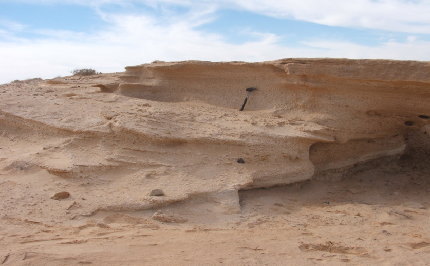
This ~200,000-year-old lake deposit in Tunisia provides evidence for the actual source of Saharan freshwater, solving the puzzle of a river that never reached the sea.

Image adapted from: Mauz et al. / CC BY (Source)

Key Findings

  • This study, focused on Libya’s Gulf of Sirt, investigated ancient river systems potentially active during a wetter period (MIS 5, 130,000-71,000 years ago) linked to human migration
  • Analysis of sediment and geological data revealed no major river system reached the Gulf of Sirt during MIS 5, suggesting limited direct freshwater flow to this area
  • Evidence indicates water accumulated in the Chott El Jerid depression in Tunisia, supporting a potential route for water from the Irharhar river system and contributing to past habitable corridors
The formation of 'sapropels', layers of organic-rich sediment on the Mediterranean seafloor, requires massive freshwater input that can slow down deep-water circulation. For decades, oceanographers have theorized that large, ancient rivers crossing the Sahara and emptying into Libya's Gulf of Sirt provided this water. A new study set out to find physical evidence of these hypothesized rivers, a quest with major implications for understanding past ocean dynamics and human migration routes. Researchers from the University of Liverpool, University of Salzburg, University of Benghazi, University of Ajdabiya, University of Gabès, Office National des Mines and Northumbria University[1] have investigated the coastal plain of the Gulf of Sirt in Libya to search for evidence of these hypothetical rivers, which may have flowed during Marine Isotope Stage (MIS) 5, a period roughly 130,000 to 71,000 years ago. The study focuses on this period because it coincides with known intervals of increased African monsoon activity and potential human migration events. The team employed a multi-faceted approach, combining field surveys to observe surface features, laboratory analysis of coastal sediment samples, and review of existing geological data from wells and surface maps. Their findings indicate a carbonate-rich, clastic-starved coastal environment during MIS 5 and early MIS 4 (roughly 74,000 to 60,000 years ago). This essentially means the coastline was characterized by relatively calm waters and limited sediment input from large rivers. Importantly, they found no evidence of a major river system reaching the Gulf of Sirt during this time. However, the study did uncover evidence of ponding – the accumulation of water – in a desert depression called Chott El Jerid in Tunisia. This discovery, coupled with existing evidence, supports a potential pathway for water flowing from the Irharhar river system northward towards Chott El Jerid. This is significant because recent research[2] has demonstrated that the Irharhar river, located further west, was indeed active around 100,000 years ago and could have formed a viable north-south migration route. This latest research builds upon earlier work that identified over 230 periods of 'Green Sahara'[3] within the last 8 million years, linking these periods to astronomical changes in Earth's orbit that influence rainfall patterns in North Africa. The chronology of these 'Green Sahara' periods aligns with the ages of archaeological and fossil hominin sites, suggesting a potential connection between climate-driven habitat expansion and hominin movements. The findings of the study contribute to a more nuanced understanding of these past wet phases. While the Gulf of Sirt did not experience a direct influx of river water, the evidence for water accumulation in Chott El Jerid strengthens the hypothesis that the Irharhar river system played a crucial role in creating habitable corridors across the Sahara. The Irharhar river, as highlighted by[2], uniquely connects monsoon-influenced mountain regions with temperate Mediterranean environments, offering both water and resources necessary for human habitation. The research highlights the importance of localized investigations, as environmental conditions varied significantly across different regions of North Africa. A critical factor for human migration appears to be the availability of non-brackish groundwater and linked oases. The finding that the Sirt coastal plain's aquifer was likely saline suggests this specific coastal area would have been inhospitable. Therefore, pre-Holocene humans likely migrated along inland groundwater-discharge paths, settling in oases rather than following this particular coastline. The absence of a large river at the Gulf of Sirt doesn't negate the existence of other viable routes, such as the Irharhar pathway, which may have been more important for human migration than previously thought.

EnvironmentEcologyOceanography

References

Main Study

1) Where did the river go? Testing the hypothesis of rivers discharging into the Gulf of Sirt (East Mediterranean) during the late Pleistocene

Published 8th October, 2025

https://doi.org/10.1371/journal.pone.0331681


Related Studies

2) Were rivers flowing across the Sahara during the last interglacial? Implications for human migration through Africa.

https://doi.org/10.1371/journal.pone.0074834


3) Dynamics of green Sahara periods and their role in hominin evolution.

https://doi.org/10.1371/journal.pone.0076514


4) Sea level change through the last glacial cycle.

Journal: Science (New York, N.Y.), Issue: Vol 292, Issue 5517, Apr 2001


Related Articles

An unhandled error has occurred. Reload 🗙