Artificial Vision Helps Identify Plants in Diverse Habitats

Greg Howard
7th September, 2025

Artificial Vision Helps Identify Plants in Diverse Habitats

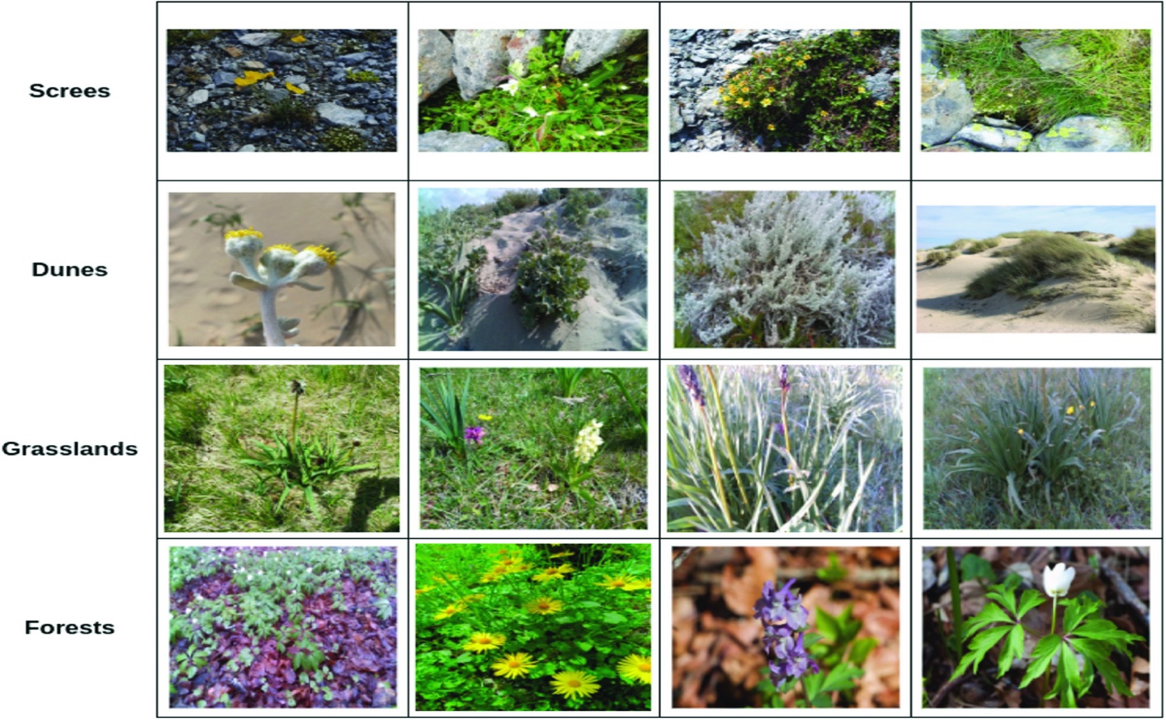
Sample images from each of the four habitats. Only a few of the species considered are displayed in this figure for brevity.

Image adapted from: Kaur et al. / CC BY (Source)

Key Findings

  • Researchers tested six AI models on plant species identification across screes, dunes, grasslands, and forests to automate habitat monitoring
  • YOLOv8 consistently outperformed other models in accurately identifying plants, even with variations in habitat and data collection methods
  • While YOLOv8 showed the best overall performance, other models sometimes detected plants missed during manual annotation, highlighting potential benefits beyond strict accuracy scores
Monitoring natural habitats is vital for conservation, but it’s a challenging task. Identifying the plant species present, particularly those that act as indicators of habitat health, is a key part of this process. Traditionally, this has relied on manual surveys, which are time-consuming and resource-intensive. Recent advances in computer vision, specifically object detection, offer a potential solution by automating species identification from images and videos. However, applying these technologies to real-world, natural environments presents unique hurdles due to the complexity of the scenes and variations in lighting and plant appearance. Researchers from Durham University, along with collaborators from the University of Perugia, National Biodiversity Future Center, Università Degli Studi di Siena, Università Degli Studi di Milano, Università di Sassari, and Al Baha University, have addressed this challenge in a recent study[1]. They quantitatively assessed the performance of six widely used object detection models – RetinaNet, YOLOv8n, Faster RCNN, Cascade RCNN, DETR, and Deformable DETR – on a novel dataset of plant species collected from four distinct habitats: screes, dunes, grasslands, and forests. The dataset is unique because it incorporates data gathered by both human surveyors and a quadrupedal robot, ANYmal C. The use of a robot to collect data is significant, building on earlier work exploring the potential of robotics in ecological monitoring[2]. While manual surveys remain common, deploying robots like ANYmal C can greatly expand monitoring capabilities, allowing for more frequent and comprehensive data collection. The data collected by the robot, combined with human-collected data, provides a robust and diverse training set for the object detection models. The researchers acknowledge that surveying habitats like “8110 - Siliceous scree of the montane to snow levels” is traditionally done by humans, and the robot data helps validate algorithms and potentially develop new methods for assessing habitat conservation status. Object detection models work by identifying objects within an image and drawing a “bounding box” around them, along with assigning a category label. The six models tested in this study represent different approaches to object detection. One-stage detectors (RetinaNet and YOLOv8n) are generally faster but potentially less accurate, while two-stage detectors (Faster RCNN and Cascade RCNN) prioritize accuracy at the cost of speed. Transformer-based detectors (DETR and Deformable DETR) represent a newer approach, leveraging attention mechanisms to improve performance. The researchers didn't simply apply these pre-trained models directly to the habitat dataset. Instead, they “fine-tuned” them – a process of adjusting the model’s internal parameters using the new data to optimize its performance for plant species identification. To further improve results, they employed techniques like “class balancing” (ensuring each species is adequately represented in the training data) and “hyperparameter tuning” (optimizing the model’s settings). The study’s findings demonstrate that the performance of these models varies significantly depending on the habitat and the specific model used. While all models showed improvement after fine-tuning, the optimal choice depends on the trade-off between speed and accuracy. This research builds on prior efforts to automatically estimate leaf area, identify species, and monitor plant diseases[3][4], but focuses on the more complex challenge of identifying plants in situ – within their natural environments. The improvements made to vegetable disease detection models[4], such as the C2fGhost module and Occlusion Perception Attention Module, highlight the importance of adapting models to specific environmental conditions, a principle that applies to this wider habitat monitoring effort. The dataset created for this study is publicly available, providing a valuable resource for the wider research community. This allows other scientists to build upon this work, developing and testing new algorithms for automated habitat monitoring and contributing to more effective conservation efforts.

BiotechEcologyPlant Science

References

Main Study

1) Artificial vision models for the identification of Mediterranean flora: An analysis in four ecosystems

Published 5th September, 2025

https://doi.org/10.1371/journal.pone.0327969


Related Studies

2) Robotic monitoring of Alpine screes: a dataset from the EU Natura2000 habitat 8110 in the Italian Alps.

https://doi.org/10.1038/s41597-023-02764-1


3) An Approach for Plant Leaf Image Segmentation Based on YOLOV8 and the Improved DEEPLABV3.

https://doi.org/10.3390/plants12193438


4) Vegetable disease detection using an improved YOLOv8 algorithm in the greenhouse plant environment.

https://doi.org/10.1038/s41598-024-54540-9


Related Articles

An unhandled error has occurred. Reload 🗙