A Distorted Polar Vortex and Winter Cold Spells in North America and Asia

Jim Crocker
1st September, 2025

A Distorted Polar Vortex and Winter Cold Spells in North America and Asia

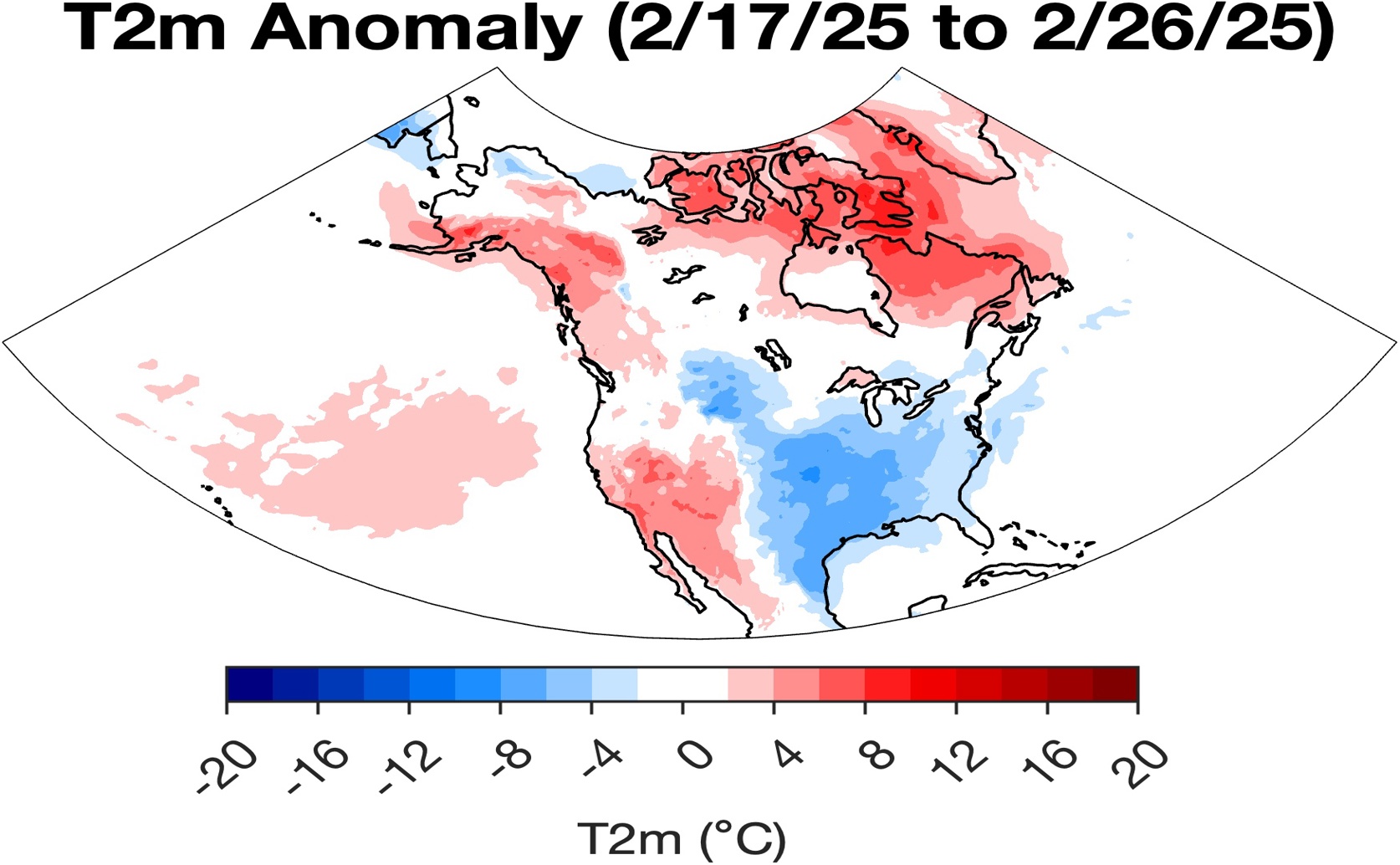
In late February, the re-establishment of the stretched Lower Stratospheric Polar Vortex over North America drove a second significant cold air outbreak, evidenced by strong negative surface temperature anomalies across the central and eastern United States.

Image adapted from: Overland et al. / CC0 1.0 (Source)

Key Findings

  • A stretched polar vortex, observed over North America and Asia in January-February 2025, was linked to prolonged cold weather in both regions
  • This stretched vortex created persistent high-pressure patterns in the atmosphere, concentrating cold air outbreaks along specific areas like the southeastern US and Korea
  • The study confirms a connection between disruptions in the polar vortex and lower-altitude weather systems, potentially improving forecasts of extreme winter events
Recent severe winter weather events across North America and Asia have prompted investigation into the connections between Arctic climate change and mid-latitude cold snaps. While the Arctic is warming at more than twice the global average rate, the relationship to weather patterns further south has remained unclear. Research from NOAA Pacific Marine Environmental Laboratory, the University of Washington, Pukyong National University, the University of Lincoln, and Universidade de Vigo[1] has focused on the role of the stratospheric polar vortex (SPV) in organizing these events. The SPV is a large-scale circulation of strong winds in the stratosphere – a layer of the atmosphere above the troposphere (where most weather occurs) – that typically circles the Arctic. Its strength and shape influence weather patterns in lower altitudes. A weakened or disrupted SPV can lead to cold air outbreaks in mid-latitude regions. The study examined a particularly notable event spanning mid-January to February 2025, where the low-level SPV (LSPV) exhibited a stretched configuration extending across North America and east-central Asia. This stretching coincided with prolonged cold weather in both regions. The research identified the LSPV, and the associated blocking patterns it created in the troposphere, as the primary organizing feature of the weather during this period. Blocking patterns refer to persistent high-pressure systems that disrupt the normal west-to-east flow of weather. The majority of weather events were observed within a west-east “wave guide” in the troposphere, meaning that the impacts were concentrated along specific longitudinal bands. In the United States, cold conditions were particularly pronounced along a corridor extending from Illinois through Mississippi and Virginia. A specific 500 mb ridge-trough pattern – a configuration of high and low pressure at a specific altitude within the atmosphere – off the west coast of California drove cold temperatures into the southeastern US, resulting in record snowfall in New Orleans. Similar cold events occurred in Korea and Eastern Asia in early February, occurring between cold air outbreaks in the US. A second cold air outbreak affected the US towards the end of February, completing the observed pattern. Importantly, while the stretched LSPV persisted for approximately one and a half months across the subarctic, the individual weather events in both the US and Eastern Asia were of shorter duration. The study also found a connection between the troughing observed in the stretched LSPV at 100 mb and corresponding “barotropic atmospheric troughing response” at lower levels. Barotropic atmospheric troughing refers to the development of troughs – elongated areas of low pressure – due to changes in the atmosphere’s density. This suggests a direct link between the SPV disruption and the formation of weather systems that brought the cold air outbreaks. Previous research has highlighted a seesaw temperature pattern with a warm Arctic and cold continents, and has suggested that changes in Arctic geopotential heights and temperatures are linked to severe winter weather in the United States[2]. The current study builds on this understanding by identifying the stretched LSPV as a key mechanism driving this relationship. [3] also demonstrated a link between disruptions of the SPV involving wave reflection and stretching and extreme cold weather, including the 2021 Texas cold wave. The findings of corroborate these earlier observations, providing further evidence that SPV behavior is a critical factor in determining mid-latitude winter weather. The research emphasizes that tropospheric weather events can coexist with the LSPV, and therefore contribute to more accurate sub-seasonal forecasting – predictions covering weeks to months. By focusing on the large-scale dynamics of the SPV, forecasters may be able to improve their ability to anticipate and prepare for extreme winter weather events.

AgricultureEnvironmentEcology

References

Main Study

1) A stretched Polar Vortex and North American and Eastern Asian Cold-Air Events during January/February 2025

Published 29th August, 2025

https://doi.org/10.1371/journal.pclm.0000679


Related Studies

2) Warm Arctic episodes linked with increased frequency of extreme winter weather in the United States.

https://doi.org/10.1038/s41467-018-02992-9


3) Linking Arctic variability and change with extreme winter weather in the United States.

https://doi.org/10.1126/science.abi9167


Related Articles

An unhandled error has occurred. Reload 🗙