Machine Learning Improves Estimates of Air Particle Levels Using Satellite Data

Greg Howard
30th August, 2025

Machine Learning Improves Estimates of Air Particle Levels Using Satellite Data

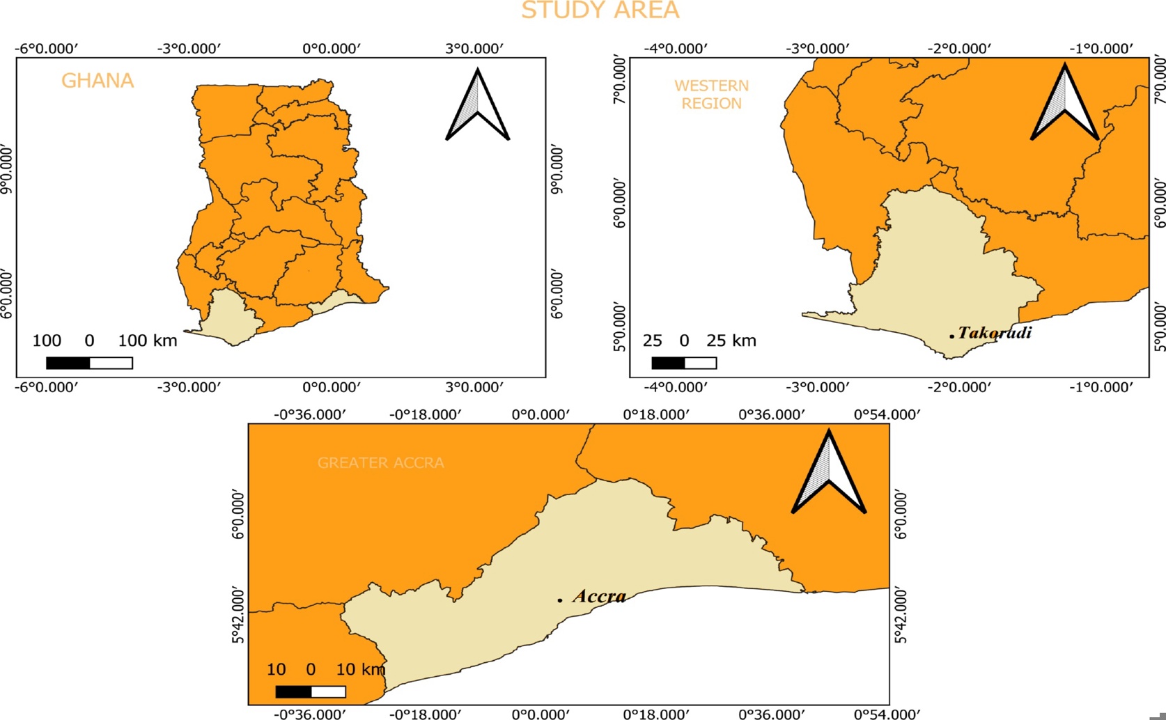
This spatial domain analysis encompasses the entire country of Ghana (left panel) while specifically targeting the urban hotspots of Takoradi (top-right panel) and Accra (bottom panel), which were selected for regional modeling due to their consistently elevated aerosol optical depth levels driven by anthropogenic and biogenic activities.

Image adapted from: Gilbert et al. / CC BY (Source)

Key Findings

  • This study mapped air pollution levels across Ghana from 2003-2019 using satellite data, revealing higher aerosol concentrations in the southwest likely due to vegetation and mining
  • A new hybrid machine learning model, combining aspects of traditional statistical methods and neural networks, most accurately predicted air pollution levels compared to standard models
  • The research identified Accra and Takoradi as cities with consistently high aerosol levels, potentially impacting public health due to vehicle traffic, industry, and coastal pollution
Air pollution is a significant global health concern, contributing to respiratory illnesses and other health problems. Accurately monitoring air quality is crucial for understanding pollution levels and implementing effective mitigation strategies. However, traditional methods of air quality monitoring, relying on ground-based stations, are often limited by their sparse distribution, particularly in developing countries. This makes it difficult to get a comprehensive picture of pollution across a region. Researchers from Kwame Nkrumah University of Science and Technology, Namibia University of Science and Technology, University of Energy and Natural Resources, Indiana University, and University of Sargodha[1] have addressed this challenge by utilizing satellite data to estimate air pollution levels over Ghana. The study, conducted from January 2003 to December 2019, focused on Aerosol Optical Depth (AOD) – a measure of how much sunlight is blocked by particles in the atmosphere. AOD is directly related to the concentration of particulate matter (PM), a key component of air pollution. The research team employed two types of predictive models: multiple linear regression (MLR) and artificial neural networks (ANN). MLR is a statistical method that establishes a relationship between a dependent variable (in this case, AOD) and one or more independent variables (like meteorological factors such as temperature, humidity, and wind speed). ANN, on the other hand, is a more complex computational model inspired by the structure of the human brain, capable of learning intricate patterns from data. A key innovation of this study was the creation of an MLR model that incorporated the structure of the ANN, aiming to improve its predictive accuracy. The data used for these models came from MODIS Aqua and Terra satellites, which provide observations of aerosols at a 3 km resolution. This allowed the researchers to create a detailed map of AOD levels across Ghana over a sixteen-year period. The findings revealed that the southwestern part of Ghana consistently exhibited higher aerosol levels compared to other regions. This is likely due to a combination of factors, including biogenic emissions – particles released from vegetation – and dust from surface mining operations common in that area. These findings align with observations made in other regions where industrial activity and natural sources contribute to elevated particulate matter. For example, a study in Santiago, Chile[2] found significant associations between air pollutants, including PM2.5, and respiratory symptoms in both asthmatic and non-asthmatic children. While the Chilean study focused on the health impacts of existing pollution, the Ghanaian research provides a tool for identifying pollution hotspots and understanding their sources. Similarly, research in an e-waste area of China[3] demonstrated a link between heavy metal pollution and respiratory issues, highlighting the importance of identifying specific pollutant sources. Interestingly, the study found that the MLR model, when structured using the ANN architecture, performed better than the standard MLR and ANN models. This suggests that incorporating the learning capabilities of neural networks into traditional statistical methods can enhance the accuracy of air pollution estimations. This is particularly important in regions like Ghana, where limited ground-based monitoring data necessitates reliance on remote sensing techniques. The research provides a comprehensive assessment of aerosol distribution across Ghana, identifying areas of concern and offering a foundation for future air quality management efforts.

AgricultureEnvironmentEcology

References

Main Study

1) Machine learning-based assessment of aerosol optical depth over Ghana, West Africa using MODIS satellite data

Published 29th August, 2025

https://doi.org/10.1371/journal.pclm.0000651


Related Studies

2) Air pollution, PM2.5 composition, source factors, and respiratory symptoms in asthmatic and nonasthmatic children in Santiago, Chile.

https://doi.org/10.1016/j.envint.2017.01.021


3) Heavy metals in PM2.5 and in blood, and children's respiratory symptoms and asthma from an e-waste recycling area.

https://doi.org/10.1016/j.envpol.2016.01.025


Related Articles

An unhandled error has occurred. Reload 🗙