How road crossings affect which species use them

Jim Crocker
30th October, 2025

How road crossings affect which species use them

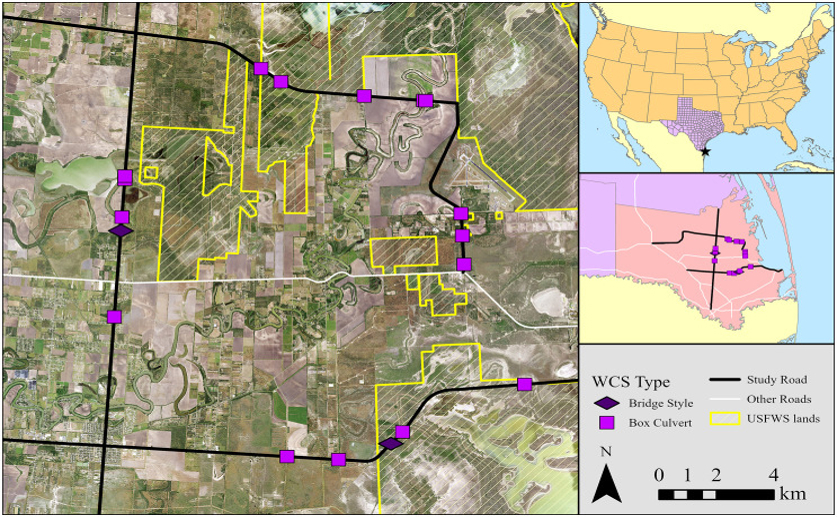
Study area showing the locations of 18 wildlife crossing structures (WCS) constructed on three highways in Cameron County, Texas, USA between 2016 and 2022.

Image adapted from: Yamashita et al. / CC BY (Source)

Key Findings

  • This Texas study examined mammal use of wildlife crossings built for ocelots to help predict future crossing effectiveness
  • Structural features of crossings and their location relative to human activity were more important than environmental factors during the first year of use
  • The study developed a predictive model to estimate mammal community composition at crossings, offering a tool for optimizing conservation efforts
Highways and roads pose a significant threat to wildlife populations globally, fragmenting habitats and leading to animal mortality through collisions[2]. To mitigate these impacts, wildlife managers employ strategies like wildlife fencing to prevent animals from accessing roads, and wildlife crossing structures (WCSs) – overpasses and underpasses – to provide safe routes for animals to traverse these barriers. While WCSs are increasingly used, determining which designs are most effective for specific species remains a challenge. This is particularly important as WCSs often benefit a wider range of species than initially intended, making a broader, community-level understanding of their effectiveness valuable. Researchers at Texas A&M – Kingsville recently developed a predictive model to assess mammal community composition at WCSs originally constructed for ocelots (Leopardus pardalis)[1]. The goal was to identify factors influencing WCS use, specifically predicting the total number of animal detections, successful crossings, and instances where animals attempted but failed to cross. This model aims to provide transportation managers and biologists with a tool to better predict which WCS designs will be most utilized, optimizing conservation efforts. The study utilized data collected via camera traps placed at WCSs. These cameras automatically record images or videos when triggered by animal movement, providing a non-invasive method for monitoring wildlife activity. The researchers then analyzed this data alongside a range of variables categorized as spatial, temporal, structural, environmental, and anthropogenic (human-related) characteristics. Spatial characteristics included the surrounding landscape features, temporal factors considered the time of year and day, structural variables described the WCS design itself (e.g., width, height), environmental characteristics encompassed factors like vegetation type and climate, and anthropogenic variables accounted for proximity to roads, human development, and land use. The initial findings revealed that, during the first year after WCS construction, the structural and anthropogenic characteristics were more influential in predicting WCS use than environmental factors. This suggests that features like the physical design of the crossing and its location relative to human activity were primary drivers of initial animal use. However, the researchers anticipate that environmental characteristics will become increasingly important over time as animals become more familiar with the structures and their surrounding habitat. The model successfully predicted the total number of animal detections at WCSs, indicating its ability to identify generally suitable locations. However, it was less accurate in predicting successful versus failed crossings. This discrepancy likely stems from the influence of finer-scale factors not captured in the model, such as localized noise levels or microclimate conditions that could deter animals from using a WCS even if it appears suitable. This research builds upon previous work highlighting the challenges in evaluating the effectiveness of ecopassages[3]. The study’s emphasis on collecting data from the outset of road projects, as recommended in[3], enabled a more robust analysis. The difficulty in assessing ecopassage effectiveness is often due to a lack of baseline data and rigorous study designs; the Texas A&M – Kingsville team’s approach addresses this by incorporating comprehensive data collection from the start. Furthermore, the study’s focus on the mammal community, rather than a single species, acknowledges the broader ecological benefits of WCSs. This aligns with the understanding that large carnivores have substantial effects on ecosystem structure and function, and their ability to move freely across landscapes is critical for maintaining these interactions[2]. The results also underscore the importance of considering landscape characteristics when placing crossing structures, as demonstrated by research on ocelot crossing use in South Texas[4], which found that structures located in areas with more herbaceous cover were more likely to be utilized. To our knowledge, this model is the first of its kind to predict WCS effectiveness for entire mammal communities, offering a generalized framework applicable to various regions and species. This framework allows conservation planners to move beyond species-specific designs and consider the broader impact of WCSs on landscape connectivity and ecosystem health.

WildlifeEcologyEvolution

References

Main Study

1) Predicting species assemblages at wildlife crossing structures using multivariate regression of principal coordinates

Published 24th October, 2025

https://doi.org/10.1371/journal.pone.0335193


Related Studies

2) Status and ecological effects of the world's largest carnivores.

https://doi.org/10.1126/science.1241484


3) Measures to reduce population fragmentation by roads: what has worked and how do we know?

https://doi.org/10.1016/j.tree.2012.01.015


4) If you build it, will they come? A comparative landscape analysis of ocelot roadkill locations and crossing structures.

https://doi.org/10.1371/journal.pone.0267630


Related Articles

An unhandled error has occurred. Reload 🗙