Best Crops For Dry Land Using Modern Water

Jenn Hoskins
21st June, 2025

Best Crops For Dry Land Using Modern Water

Location maps of the studied area.

Image adapted from: Abuzaid et al. / CC BY (Source)

Key Findings

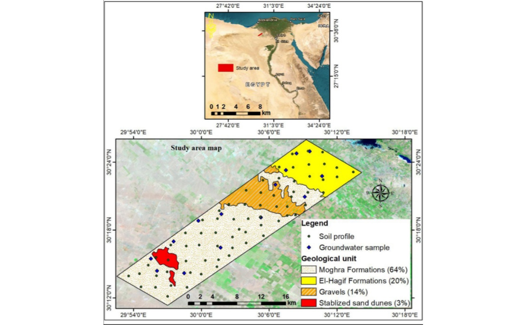
  • Researchers in Egypt developed a new mapping tool to identify the best lands for specific crops, finding that wheat is most suitable, followed by maize, and then broad bean
  • Groundwater quality was the most critical factor for crop success, followed by soil conditions like salinity and depth, and then climate
  • While winter crops like wheat are highly suitable, summer crops like maize face climate challenges, and some areas are unsuitable for broad bean due to water quality
Feeding a growing global population with healthy food while preserving natural resources is a monumental challenge of our time. In arid regions, this challenge is particularly acute, as agricultural expansion often strains scarce freshwater supplies and can lead to land degradation. Traditional methods for assessing which lands are best suited for specific crops often rely on manual evaluations, which can introduce uncertainty and subjectivity, leading to inefficient use of precious resources. Addressing this critical issue, researchers at Benha University have introduced a novel framework to objectively determine the most suitable agricultural lands for cultivation, specifically focusing on wheat, broad bean, and maize under center pivot irrigation systems in an arid region of the western Nile Delta fringes, Egypt[1]. This study aims to provide a more precise and data-driven approach to land assessment, moving beyond the inherent limitations of older, less systematic methods. The core of the Benha University study lies in integrating advanced analytical tools: the Analytical Hierarchy Process (AHP), fuzzy logic, and a Geographic Information System (GIS). AHP is a structured technique for organizing and analyzing complex decisions. It breaks down a problem into a hierarchy, allowing decision-makers to compare different factors (like soil quality, climate, or water availability) in pairs and assign a relative importance or "weight" to each. This helps in systematically prioritizing criteria. Fuzzy logic, on the other hand, is a mathematical approach that deals with concepts that cannot be defined as simply true or false, but rather as degrees of truth. For example, instead of a soil being either "suitable" or "unsuitable," fuzzy logic allows for degrees like "moderately suitable" or "highly suitable," reflecting the continuous nature of environmental factors. GIS acts as the platform that brings all this spatial data together, allowing for the creation of maps that visually represent the suitability of different land areas. The process involved collecting extensive data, including local climate conditions, landscape characteristics from a digital elevation model, and detailed analyses of seventy soil profiles and fourteen artesian wells to assess irrigation water quality. This comprehensive data collection is crucial, as the suitability of land is determined by a complex interplay of environmental factors. For instance, previous research on land suitability for wheat cultivation in Iran also emphasized the importance of soil characteristics and land limitations, identifying factors like slope, soil depth, and salinity as critical determinants[2]. The main and sub-criteria derived from this data were then subjected to AHP to determine their relative importance. For example, the study found that groundwater quality contributed significantly (46%) to site suitability, followed by landscape factors (42%) and climate conditions (13%). This systematic weighting ensures that the most impactful factors are given due consideration in the final assessment. Using GIS, raster layers (grid-based maps) were created, with each cell assigned scores based on fuzzy membership functions, reflecting how well it met the requirements for each specific crop. These layers were then combined using a weighted sum algorithm to produce the final crop suitability maps. This methodological approach builds upon and refines earlier efforts in land assessment. For example, a study on land suitability for wheat in northwestern Iran demonstrated that the ANP-fuzzy method (a close relative of AHP-fuzzy) provided a more accurate evaluation than traditional parametric methods, specifically in identifying limiting characteristics such as soil depth, pH, and salinity[2]. Similarly, the effectiveness of the AHP method in logically determining the weights of multiple parameters for land suitability was also highlighted in a study assessing land for tomato cultivation[3]. The Benha University researchers have effectively integrated these proven analytical techniques into a comprehensive framework, addressing the inherent uncertainty and subjectivity often found in traditional land evaluation. The findings of the Benha University study offer valuable insights for sustainable agricultural planning in arid regions. The results indicated that climate conditions in the studied area were highly to moderately suitable for winter crops like wheat and broad bean, but only marginally suitable for the summer crop, maize. Key limiting factors for landscape suitability were identified as soil salinity, sodicity (excess sodium), and depth. While much of the land was suitable for the selected crops, certain areas (193 hectares for broad bean and 275 hectares for maize) were found to be currently unsuitable, primarily due to potential salinity and specific ion toxicity hazards from groundwater irrigation. The study concluded that wheat cultivation should be a high priority in the region, with 90% of the area falling into highly or moderately suitable categories. Maize ranked second, with 55% highly suitable, and broad bean third. These specific suitability maps provide actionable data for farmers and policymakers, guiding decisions on which crops to cultivate in specific areas to maximize yield and resource efficiency. This directly supports the broader goal of transforming agri-food systems towards sustainable satisfaction of healthy dietary needs, as highlighted in earlier research concerning Egypt's food security challenges[4]. By optimizing crop allocation based on detailed land suitability, it becomes possible to enhance food production while simultaneously reducing the intensive consumption of freshwater resources, a critical step towards achieving sustainable food and nutrition security in the region[4]. The framework developed by Benha University offers a replicable model for sustainable food crop production in other dryland areas facing similar challenges.

AgricultureSustainabilityPlant Science

References

Main Study

1) A comprehensive crop suitability assessment under modern irrigation system in arid croplands

Published 18th June, 2025

https://doi.org/10.1371/journal.pone.0326183


Related Studies

2) Applying fuzzy inference system and analytic network process based on GIS to determine land suitability potential for agricultural.

https://doi.org/10.1007/s10661-022-10327-x


3) Soil classification and land suitability evaluation for tomato cultivation using analytic hierarchy process under different land uses.

https://doi.org/10.1016/j.heliyon.2025.e41681


4) Optimized crop distributions in Egypt increase crop productivity and nutritional standards, reducing the irrigation water requirement.

https://doi.org/10.1016/j.scitotenv.2024.175202


Related Articles

An unhandled error has occurred. Reload 🗙